Chicago forecast: Multiple waves of heavy rain, isolated storms through Thursday

Multiple waves of rain showers are set to move through the Chicago area Wednesday, with additional rounds of rain lasting all day Thursday that could lead to significant flooding.
About 5:30 a.m., Live Doppler 5 showed light rain falling in the city, surrounded by heavier showers to the south and west. About 7 a.m., the rain was expected to spread across the entire Chicago area and through the morning commute.
NBC 5 Storm Team Meteorologist Iisha Scott warned that the rain could be heavy at times, with isolated storms possible.
Rain will continue into the afternoon, Scott said, though it won’t be as widespread. By about 2 p.m., the rain will is expected to remain mostly south of I-88.
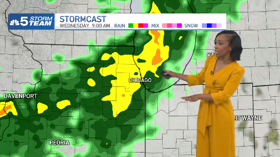
Wednesday night into Thursday, more rain was expected, with lightning and rumbles of thunder. Thursday morning, showers are expected to stay mostly north and west of the city.
By Thursday afternoon, the rain will once again become widespread, Scott said, with showers and some storms through the Thursday evening commute.
By about 3 a.m. Friday, the rain will move south and into northwest Indiana.
Flooding concerns
The National Weather Service placed counties to the north and west under a moderate flood risk Wednesday, which ranks as level 2 of 4. On Thursday, the entire Chicago area will face a moderate flood risk, with “significant” rises on rivers and streams possible, the National Weather Service said.
Most areas will see between 2 to 3 inches of rain by Friday, though some locations could see higher totals.
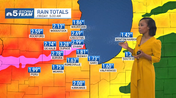
“On average, about 1 to 3 inches,” Scott said.
Cooler temperatures are expected behind the storm system, Scott said, with temperatures in the upper 60s and low 70s Wednesday and Thursday, followed by temperatures in the 60s Friday and into the weekend.

 点赞
点赞 收藏
收藏 点踩
点踩 分享
分享