Mapped: How Islam (not Germanic invaders) likely ended antiquity

In 1922, the Belgian medievalist Henri Pirenne wrote, “Without Islam, the Frankish Empire would never have existed, and without Muhammad, Charlemagne would be inconceivable.”
That controversial thesis ignited a century of trench warfare across history faculties. Bone of contention: What actually ended the ancient world? Was it the Germanic invasions, the Justinian plague, moral decay, the conversion to Christianity, or simply too much lead in the imperial plumbing that drove the emperors mad?
The most conventional endpoint — the one you probably learned in school — is 476 A.D., when Romulus Augustulus, the last emperor in Rome, was deposed by Germanic chieftain Odoacer, marking the fall of the Western Roman Empire.
Now, these maps support Pirenne’s two main points: that it was the rise of Islam in the 7th and 8th centuries, and not the barbarian invasions of the 4th and 5th centuries, that put an end to late antiquity. And that by splitting the Mediterranean-centered world or the Roman Empire in two, Islam created the conditions for the rise of northern Europe.
More than half a million coins
The proof was delivered not by historians but by economists. Johannes Boehm (Sciences Po, Paris) and Thomas Chaney (University of Southern California, Los Angeles) did something that Pirenne lacked the computing power to do. They created a database of more than half a million coins minted between 325 and 950 A.D., recording not only where and when each was minted, but also where and when they were found — down wells, as grave gifts, in treasure hoards, and so on.
In effect, they transformed ancient loose change into GPS pings from the past. And while one coin minted in, say, Alexandria and found in Burgundy is merely evidence of a single connection, thousands of such finds aggregated over centuries — carried by merchants, soldiers, pilgrims, tax collectors, looters, and surely more than a few drunken sailors — reveal trade routes, the intensity of economic contact, and shifting patterns of exchange.
This is economic history by way of forensic numismatics. And the result is something like an economic CT scan of the late Roman to early medieval world, with six centuries of data analyzed for “Trade and the End of Antiquity,” a working paper by Boehm and Chaney.
From Constantinople to Friesland
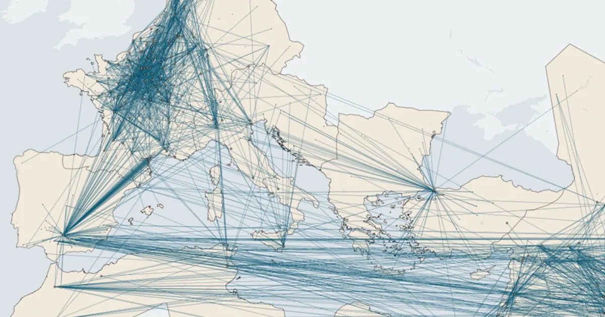
These maps show two timeframes near the beginning and end of the period they examined. In red, we see coin flow from 450 to 630 A.D., before the Arab conquests. In blue: coin flow from 713 to 900 A.D., after Muslim armies conquered the Middle East, North Africa, and Spain.
Before the conquests, the Mediterranean looked like a giant metallic whirlpool centered on Constantinople, then the capital of the Eastern Roman Empire. Coins radiate outward and flow back across imperial highways and sea lanes to nearby places (Greece, Anatolia, Syria, the Balkans) and farther off (Egypt, Italy, North Africa). Even the connections to northern Europe are robust, with thick lines linking Constantinople to Friesland and Dorestad in the Netherlands.
The map after the conquests is a nervous breakdown in cartographic form. Constantinople has collapsed. It still sits at the center of an economic web, but it’s a much frailer, thinner one. The old north-south arteries across the Mediterranean have atrophied. If on the first map the formerly Roman Mare Nostrum still looked like a tightly integrated commercial web, the second one looks like someone cut the sea in half with a ceremonial scimitar.
A century of rapid expansion
That’s kind of what happened. For a century after Muhammad died in 632 A.D., Muslim rule expanded rapidly from the Arabian Peninsula across the Middle East and North Africa, all the way to Spain. Early Muslim expansion reached its high-water mark at the Battle of Tours (732 A.D.), where the Franks reversed their march into northern Europe.
Their more permanent conquests farther south created a rupture. Antiquity was essentially a Mediterranean-centered civilization. Rome was not just an empire around a sea; it was an empire because of a sea. It was Rome’s superhighway, its fiber-optic cable. Across three continents, the Mediterranean transported grain and wine, old wisdom and new religions, soldiers and slaves.
Even more so than Rome, Constantinople was a maritime capital: It sat astride the Bosporus like a tollbooth between Europe and Asia, the Black Sea and the Mediterranean. The advent of Islam turned that unified economic zone into a new geopolitical frontier, and trade across that new dividing line diminished sharply.
So it seems the key argument of Pirenne’s 1937 posthumous work “Mahomet et Charlemagne” rings true: The Germanic invasions may have ruptured the political fabric of the late Roman world, but not its commercial unity. That was shattered when the Arab conquests cut Christian Europe off from its eastern markets, forcing a new northern center of gravity. It wasn’t the Visigoths who ended antiquity but rather the Caliphs. To put it another way: Modern Europe owes its existence to its civilizational competitor, the Islamic world.
Worse than the Justinian plague
Of course, not everyone will be convinced by this evidence of the validity of Pirenne’s thesis. One camp will continue to argue, as Chris Wickham does in Framing the Early Middle Ages (2005), that the Roman commercial network across the Mediterranean had already collapsed before the Arab conquest. The other will maintain, like Michael McCormick in Origins of the European Economy (2001), that trade survived the conquests just fine.
But the coin flow data is compelling. Cross-Mediterranean flows break down in precisely the same period as the century of conquest, and do so more sharply than during either the Vandal sack of Rome (455), the abdication of Romulus Augustulus, or the Justinian plague (541).
But let’s give discredit where it’s due: Pirenne was not entirely right. He may have had a better idea than most about the timing and cause of the rupture between antiquity and the Middle Ages, but he was wrong about its effects. In his thinking, the break was an economic catastrophe.
As the center declines, the margins rise
The second map shows something else: Trade does not stop; it reorganizes itself. As the Mediterranean center declines, the margins rise. At its peak in the early 8th century, the Middle East under the early Umayyads and Abbasids was the richest region in the world. And inside the Islamic world, a new east-west corridor connects that center of gravity with recently Islamicized North Africa and Spain.
Things also look up on Europe’s Atlantic fringe. By the end of the 9th century, the continent’s economic center of gravity had shifted away from Constantinople toward Frankish Europe and the Low Countries, places late-antiquity Romans would have dismissed out of hand as damp, dark wilderness, inhabited by too many people called Chlodwig.
Yet these regions were now the wealthiest parts of the ancient western world and would remain ascendant, forming the nucleus of medieval and, later, modern Europe. Cue Charlemagne, grandfather of modern Europe, who in 800 A.D. would make the damp, northern city of Aachen his imperial capital.
Thanks to the economic archaeology of Boehm and Chaney, we now have hard data to back up the butterfly effect linking Muhammad to Charlemagne and the rest of European history.
Strange Maps #1293
Got a strange map? Let me know at strangemaps@gmail.com.
Follow Strange Maps on X and Facebook.
This article Mapped: How Islam (not Germanic invaders) likely ended antiquity is featured on Big Think.

 点赞
点赞 收藏
收藏 点踩
点踩 分享
分享